| Estes Sites: |
 |
") |
 |
 |  |
| Estes Sites: |
|
|
|
| |
This page is an extract from "The Estes Family" by Stewart Estes, (c) 2009
DEAL, KENT
The earliest Estes ancestors of which we know are found in Deal -- a town in Kent, England. It lies on the English Channel eight miles northeast of Dover. It is a small fishing community situated between Dover and Ramsgate. Closely associated with Deal are the villages of Kingsdown, Sholden and Walmer, the latter believed to be where Julius Caesar first arrived in Britain.1 From the time Julius Caesar landed nearby, Deal became an important defensive position. Henry VIII chose it for the largest of his coastal forts and Deal Castle was held in readiness again during the Napoleonic Wars - when the Time Ball Tower was used to semaphore messages to London. The once busy Admiralty Dockyard in Deal has disappeared, but there are still many attractive period houses in and around Middle Street and the town’s strong maritime connections are kept alive by the fine local history and maritime museum in St. Georges Road.
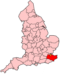
county Kent
Archaeological evidence shows that Deal has been occupied at least since the Stone Age: many Roman artifacts have been found as well as a Celtic figurine (known as the Deal Man) and an Iron Age warrior buried with his armor.
Julius Caesar landed at Deal on 25 August 55 B.C. to violent opposition from the local Britons. He established a bridgehead on the shore, but had to return to Gaul (France) after a severe storm scattered and wrecked many of his galleys carrying the Roman cavalry. Returning the following year he made further inroads into the countryside, defeating the local tribes on the Barham Downs, but the weather once more caused mayhem with the galleys on the beach and sent him scuttling back to Gaul for a second time.
It would be almost 90 years before the next (this time successful) attempt by Aulus Plautius, who landed along the coast at Richborough in 43 A.D.
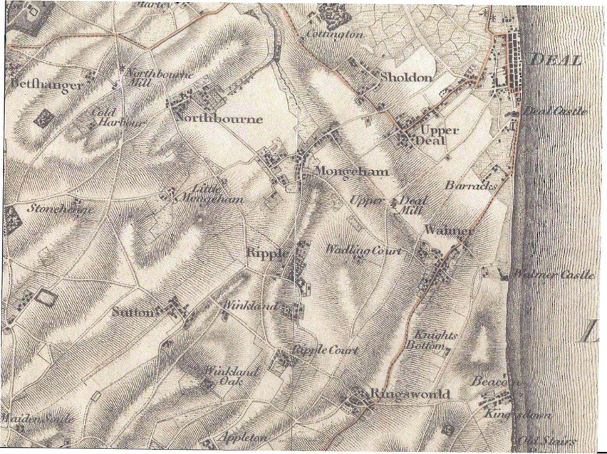
Until the 15th century, Deal was an agricultural community, centered around the Parish Church of St Leonard; an area now known as Upper Deal. The coastal area was largely marsh-land, washed by the sea at high tide. By the time the three castles were built by Henry VII in 1539/40, the shingle bank had built up and the marshland had dried up, making it possible for the area to be colonized.
All of the land along the foreshore (the present town center) was owned by the See of Canterbury and it was the Archbishop, William Warham, who planned the development of the area around Middle Street in the early 1500s, most of which still exists today. The Archbishop was also responsible for setting (and collecting!) the rents for the properties. As people moved into the new town a new type of community developed, relying mainly on the sea for a living. Leyland (c.1540) described Deal as a "fyssher village", but much of the work of the local boatmen was related to the shipping in the Downs: ferrying pilots, crew and passengers to and from the shore; carrying stores and victuals to supply the ships; rescuing people wrecked on the Goodwin Sands; and salvaging ships and cargo from the "Shyppe Swallower." In the days of sail, as many as 300 vessels could be seen lying at anchor in the Downs in bad weather.
Early 18th century State Papers describe Deal as one of the four great English naval ports, along with Portsmouth, Plymouth and Rochester. Although Deal has never had a harbor, there were proposals to build one in the 19th century, and shares were issued in a company to undertake the project.
The Naval Dockyard never had any docks; it was mainly used as a victualling and supplying station for the hips in the Downs, although some small vessels were built on the beach. It occupied the area of land between the beach in the east and Prospect Place (Victoria Road) in the west, and South Street to the north and the Castle in the south. After the closure of the yard in the 1800s, the land was bought up for housing and the area became known as Victoria Town.
Horatio Nelson once said of Deal, "This is the coldest place in England, most assuredly." The center of the town is below sea level and the area is very flat, exposed to the bitter north and east winds off the sea.
Upper Deal today is linked to Sholden, Mill Hill and Mongeham and forms the southern part of the town. Upper Deal is furthest from the sea, and was probably the highest inhabited part of the town (although only a few feet above sea level). The town of Deal grew up around the church and the manor house as a farming community. It was not until the sea gradually built up a shingle bar and allowed the coastal marshes to dry out that people started to migrate towards the coast and fishing became the main occupation. Gradually, a new town grew around the fishing grounds. Later, the Naval Dockyard increased the town's dependence on the sea.
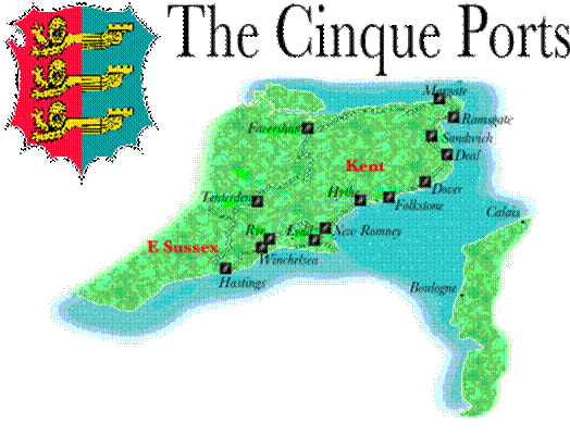
Deal was named as a '’limb port'’ of the Cinque Ports in 1278. The Confederation of Cinque Ports is a historic series of coastal towns in Kent and Sussex, at the eastern end of the English Channel where the crossing to the continent is narrowest. It was originally formed for military and trade purposes, but is now entirely ceremonial. The name is Norman French for "five ports" – the five being Hastings, New Romney, Hythe, Dover, and Sandwich. They are supported by the two ancient towns of Rye and Winchelsea, whose councils traditionally maintained defense contingents for the realm of England. Apart from the five ports and the two ancient towns, there are seven other members of the Confederation, which are considered to be Limbs of the other towns. These are Lydd (Limb of New Romney), Folkestone, Faversham and Margate (Limbs of Dover), Deal and Ramsgate (Limbs of Sandwich) and Tenterden (Limb of Rye).
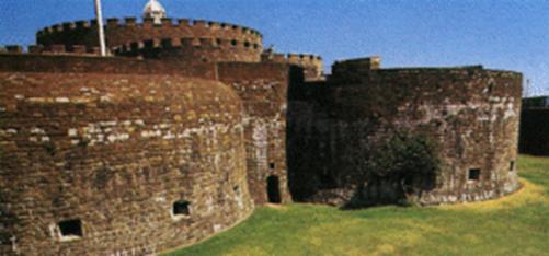
Due to its position on the Downs, the town grew to become for a while the busiest port in England; today it enjoys the reputation of being a quiet seaside resort, its quaint streets and houses the only reminder of its fascinating history. The coast of France is approximately twenty-five miles from the town, and is visible on clear days. Its finest building is the Tudor Deal Castle, commissioned by King Henry VIII and designed with an attractive rose floor plan. The Town Motto is "Adjuvate Advenas" (Befriend the Stranger).
The Domesday Book records the obligation of the ports to supply ships and men to the King once a year. This ship service continued for over three hundred years until larger ships were needed by the Navy. The privileges obtained by the Cinque Ports were set down in a series of Royal Charters-the last one granted by Charles II in 1668, can be seen in the Guildhall, Sandwich. These privileges included freedom from tolls and customs duties, freedom to trade and to hold their own judicial courts.
During early medieval times, Deal began to grow faster than the other three villages as more of its inhabitants where able to find employment in fishing. The village fishermen built rough shelters on the shingle beach, which was steadily growing seawards. Their pathway from the village to the sea, trodden for centuries, later became known as Church Path, which is still in existence for much of its length. It started at the village center, opposite St Leonard's church, and passed eastwards to the sea, crossing the marshy wastelands between. The carriage of some goods and passengers across the Channel occurred via Deal, although most went via Dover and Sandwich. By the mid-14th century, Deal and Walmer had become "limbs" of Sandwich in the Cinque Ports organization, and had to provide the King with ships during times of war.
By the 16th century, Deal's shingle beach had grown to produce a barrier between the sea and the low-lying marshland. The marshland was then able to be drained, and agricultural output increased. The growth of the beach also led to an increase in shipping in the area. The harbors at Sandwich and Dover were becoming blocked by shingle and were unable to be used by larger ships. During unfavorable weather, ships instead began to use the Downs, an area of sheltered sea between Deal and a sandbank six miles east, known as the Goodwin Sands. This provided further employment for village inhabitants, who supplied the ships lying in the Downs with stores, fresh water and sometimes emergency equipment. Buildings began to appear on the newly created land by the sea, at first for businesses servicing ships, and later for residential purposes as well. After the dissolution of the monasteries in the 1530s, the three manors of Deal, Deal Prebend, Court Ash and Chamberlain's Fee, passed to the King. Deal Prebend and Court Ash were granted to the Archbishop of Canterbury; Chamberlain's Fee was kept, and in 1599 passed into private ownership.
Deal is full of old buildings and many have an extensive smuggling heritage - under the town is a warren of smugglers tunnels - often leading to local churches. The character in the town comes from the almost random styles and eras of houses all put together. Looking back at the town from the end of the pier gives a good impression of the rich history of the town. Many of the original buildings from the 1800's are still visible notably a collection of shops on Victoria Road, formerly Prospect Place - one still offering a Pharmacy.

Deal Castle
(Photograph by Harold Wyld)
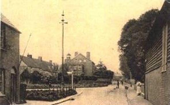
Deal
The photograph above was taken from the end of Middle Deal Road near the junction with London Road, looking south towards St Leonard's church. The top of the church tower can be seen over the roof of the house in the center. The view has changed little today, except that the cottages are obscured by trees.
St. Leonard’s Church, Deal
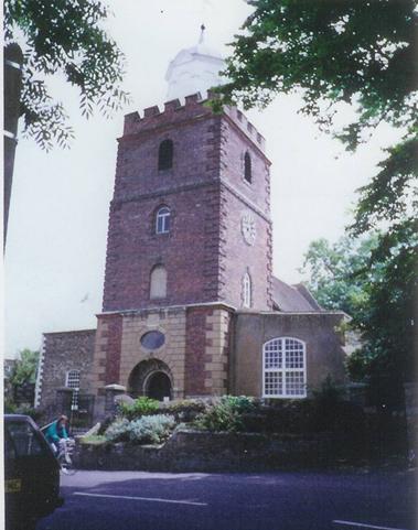
St Leonard’s Church, Deal
London Road & Manor Road
(Photograph by Larry Duke)
St. Leonard's is the parish church of Deal. For centuries, before the building of St. George's Church in the town centre, it was the only church in the town. The church stands on a rise at the junction of Rectory Road, Manor Road and London Road, surrounded by trees. The church is brick-built, with a tower topped by a cupola. The main part of the churchyard is separated from the church by Manor Road. Like so many English churchyards, most of the memorials have been removed from the graves and stacked around the walls.
Inside St Leonard’s Church in Deal
St Leonard’s church in Deal, Kent is a remarkable structure which incorporates work from many centuries. From the outside it is obvious that the church has been clothed in an outer layer of brick and render, but occasional medieval stonework appears from under the skirts.
The west tower is a Georgian structure and it is through this that the church is entered. The vestibule contains the first of what will be a fine collection of 15 hatchments and benefaction boards showing that this was once a very wealthy place. The layout is somewhat confusing. In front is an empty space that should be the nave, leading into a very small medieval chancel. To the south is an aisle and chapel but to the north is a veritable auditorium facing south and surrounded on three sides by huge balconies improbably lit by circular windows.
